
A line of barbed wire caught Keri York’s eye as she ventured down a sketchy trail leading south from Riverside Pond and the site of Hailey’s former sewer treatment plant.
“We’ve got a lot of barbed wire we need to remove and some other fencing, as well, as we turn this into a nice walking path,” York said. “And we’ll have to create a little path through Heagle Park to connect this path to that leading to Draper Preserve.”
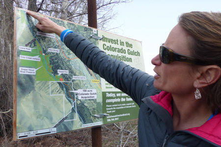
Keri York points to a Land Trust informational sign on the Hailey Greenway. Photo by Karen Bossick
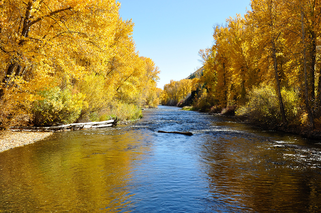
York is director of conservation at the Wood River Land Trust, which is involved in a major project to restore the Big Wood River running through Hailey, even as it extends the Hailey Greenway walking path along the river.
The Hailey Greenway extension was made possible by the nonprofit organization’s purchase of 150 acres of private property in the Colorado Gulch area in December 2016.
The Land Trust board held a wire-cutting, rather than a ribbon-cutting there, in a blinding snowstorm, cutting 50 yards of barbed wire fence that had marked the
private property.
It was a symbolic move that indicated the public would be ensured access to popular hiking areas on the west side of the river that had been off-limits before.
The extension of the Greenway is the project Wood River Valley residents will notice this summer.
The Land Trust wants to build a better footbridge across the canal there, replacing a wooden plank. It also wants to remove noxious weeds and plant 14 acres that have been used for grazing with native grasses and wildflowers to enhance the smorgasbord for small mammals and provide better habitat for birds.
And it hopes to improve the trail in the area and connect it to the Hailey Greenway, which starts 1.5 miles to the north near Lions Park. The project would double the size of the Greenway.
“The plan is to have it done by Thanksgiving when runners take part in the Annual Turkey Trot to Draper Preserve and back,” said Mike McKenna, the Land Trust’s community engagement coordinator.
One of the benefits of the acquisition is that the Land Trust may be able to allow some seasonal flooding in that area to help the river access its historic floodplain, York said.
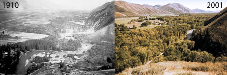
View of the meandering river in Hailey in 1910; and view of the straightened river in 2001. 1910 image courtesy The Community Library Regional History Department
She pointed to boulders along the bank put in by the county and city to keep the river from flooding the sewer treatment plant and nearby homes.
Then she pointed to a 1910 photo taken by Hailey photographer Martin Mallory that showed the area as it featured a meandering river with islands and a robust cottonwood forest. Side channels coming into the river provided gravel bars and sandbars—good habitat for fish.
A picture taken of the same site in 2001 showed the river had straightened. Much of the cottonwood forest was gone.
“We want to see if we can restore some of the natural meandering, using root wads and trees in place of the boulders,” York said. “A study we did showed that the area from Bullion Street to Colorado Gulch is one of the highest priorities for restoration along the entire Wood River. The fact that we now own this property may make it easier to mitigate things naturally.”
That study—a $180,000 Biota Research study sponsored by the Land Trust, Trout Unlimited, and Bureau of Land Management—showed that the Big Wood River needs help.
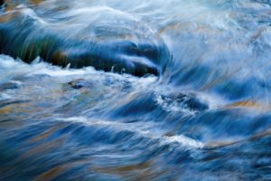
Homeowners have installed riprap along the banks, straightening stream banks and speeding the flow of the water, rather than allowing the river to meander and create holes for the trout. The river has actually been straightened for 17 miles as it courses through the Wood River Valley, losing two miles in length, said York.
The area north of the Bow Bridge once served as the site of an old lumber mill and the city dump where people dumped things in the river, she added.
“That stretch looks pretty, but it’s not very healthy. The study showed that the river there has widened from what it used to be. It’s not able to transport sediment downstream properly. And there’s been a lot of erosion on the stream banks.”
The degradation has negatively affected the trout population in the river, the quality of the banks for wildlife and plants and the overall health of the region’s largest aquifer, York added.
The Land Trust cleaned up the area several years ago, removing appliances and even a car out of the river. Volunteers removed noxious weeds, and workers installed some drop structures, or rocks, in the river to enhance the trout habitat.
Now the Land Trust hopes to install bigger rocks, level the slopes and plant sedges, rushes and other native grasses along the bank to reduce erosion.
The Land Trust had hoped to get started on the Bridge-to-Bridge project this summer but decided to wait until the Master Plan for the Hailey Greenway is finalized. Consequently, the work will probably not start until the summer 2018.
“But it’s something to look forward to,” said York. “When restored, fishermen should enjoy better fishing, and walkers should have a better chance of seeing more wildlife.
More Local Buzz: Ketchum Update
Whatever Happened to the Play Waves for Kayakers?
The Wood River Land Trust spent several years working with the Bureau of Land Management and the City of Ketchum to restore the Big Wood River near the Hulen Meadows Pond. The proposal even included creating some play waves for whitewater kayakers along the river there.
But that project is dead in the water, said Mike McKenna, community engagement coordinator for the Wood River Land Trust. “It was too much of a battleground. We decided to focus our attention, instead, on the Big Wood River as it runs through the Valley. It’s not in great shape, with more than 50 percent altered by man,” he said. The City of Ketchum spent a lot of money on an environmental assessment for the project in Hulen Meadows, but the BLM kept requiring more and more information until the city decided not to pursue it further, said Keri York, the Land Trust’s director of conservation.
Some Hulen Meadows residents are unhappy about the pond filling with sediments. “But it was created to trap sediments,” said York. “It’s designed to fill in, but in the meantime it became a recreational amenity. There’s still an opportunity for the community to restore the area. We’ll just to have to see what happens.”